SETTLEMENT ARCHAEOLOGY ON THE AMBER ROAD: THE VILLA OF BRUCKNEUDORF AND THE VILLAGE OF THE BOII
The Roman villa of Bruckneudorf and its Celtic predecessor settlement are being investigated in a long-term research project by the ÖAI. The Masterplan Archäologie initiated by Land Burgenland provides the framework for intensive scientific analyses and knowledge transfer by Stefan Groh and Helga Sedlmayer from 2024-2026. The two main topics of research are: Celtic settlement activity in the Bruckneudorf area (civitas Boiorum) of the 1st to early 2nd century AD on the one hand and the late antique monumental villa of the 4th century AD on the other.
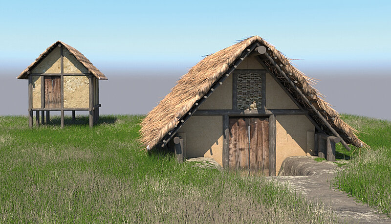
Bruckneudorf (Burgenland) was already a traffic junction in antiquity. In the region where the A4/A6 motorway junction is located today, a villa rustica was built in the late 1st century AD. The Roman fundus was implemented in the traditional area of the Boii (civitas Boiorum). The Boii settled south of the floodplains of the Leitha river in simple, small-scale pit-houses, and then in the course of the 1st century AD also in larger arcaded houses. The favourable location along the Amber Road was decisive for the prosperity until the expansion of the monumental villa of Bruckneudorf at the culmination point in the 4th century AD.
The function of the 12.5-hectare villa complex at Bruckneudorf, which was magnificently furnished in late antiquity and excavated by the ÖAI between 1931 and 2003, is still under discussion. In a new research approach, geophysical prospection led to the discovery of ten further buildings in the villa complex, which shed new light on the diachronic and functional development. In the updated plan of the entire complex, one burial building stands out in particular, which as a mausoleum - probably from the Tetrarchic/Constantinian period - may have symbiotically connected the ‘world of the dead’ and the ‘world of the living’.

The fertile plains of the Carnuntum hinterland have been exploited intensively since the Bronze Age. The Roman site of Bruckneudorf (Burgenland), which is located just 11 kilometres from the civilian town of Carnuntum in the catchment area of the Amber Road, is of particular importance here. In Bruckneudorf, on a plain bordered by the Leitha Mountains to the west, the Leitha River to the north and east and Lake Neusiedl to the south, on the edge of a settlement of the Boii a villa complex developed, which would soon have had a central function.
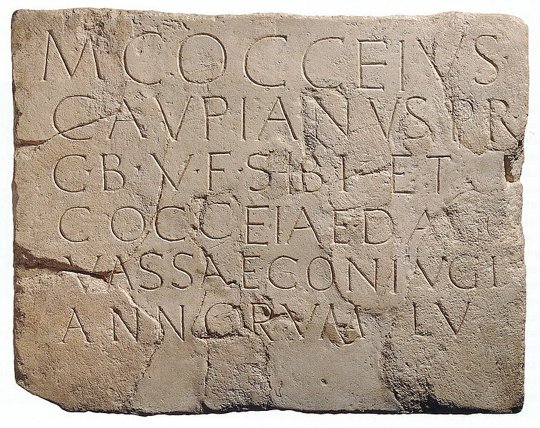
The villa complex, originally built on Celtic territory - the gravestone of Marcus Cocceius Caupianus, pr(inceps) c(ivitatis) B(oiorum) has been documented for the early period - was expanded into a walled 12.5-hectare farm in the Middle Imperial period. A palatial design of the central residential building with rich mosaic and wall painting decoration is attested for Late Antiquity, which is often associated with the presence of the imperial family of Valentinianus I in Carnuntum.
Archaeological Field Research
Archaeological excavations by the ÖAI took place in the villa complex with interruptions from 1931 to 2003. The overall floor plan, with at least 17 individual buildings or structures, is based on the excavations by Balduin Saria (1949-1955). Gerhard Langmann (1975-1978) and Heinrich Zabehlicky (1994-2003) focussed their field research on the central residential building. Outside the villa complex, investigations were carried out as early as 1851 in a late antique burial ground and, in the course of the motorway constructions (A4/A6), large-scale excavations of the Celtic settlement and of sections of the monumental villa were supervised by the Bundesdenkmalamt in 1990, 2002-2004 and 2020-2021.
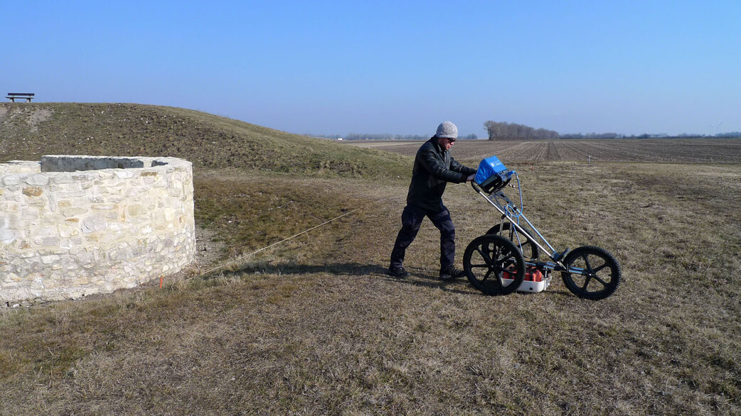
What was missing until then was an overall view of both the buildings in the villa area and those in the surrounding area, which can only be generated by large-scale excavations or non-invasive geophysical prospection and GIS-supported settlement analyses. As part of the new project, geophysical surveys were carried out over an area of 9.5 ha with magnetics and 6.5 ha with georadar, with the aim of checking and remeasuring the location of the old features on the one hand and verifying areas previously defined as free from construction on the other.
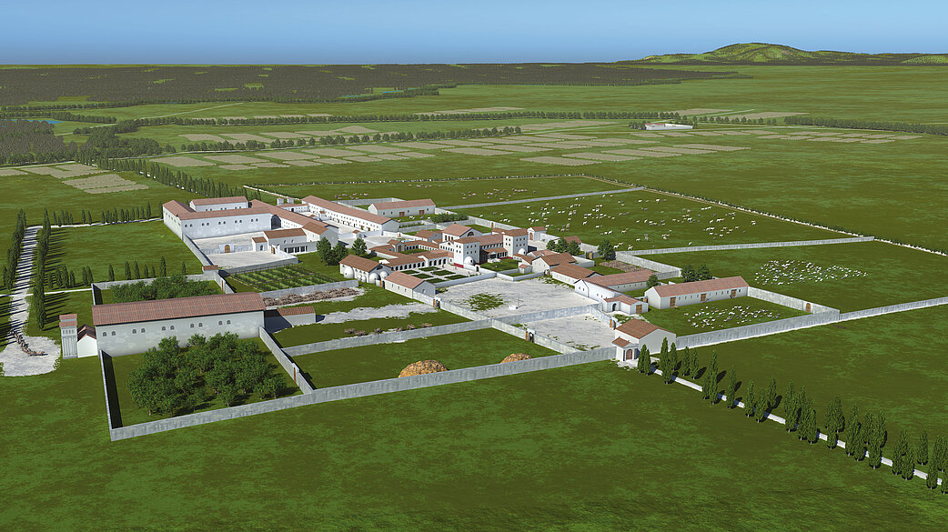

The prospection data not only allowed the correct location of the old excavation findings, but also a new assessment of the entire villa complex. Ten additional, partly overlapping buildings located in the central area of the villa could be recognised, whose diverging orientations suggest either a diachronically changing settlement development and/or different areas of activity. One important result is the integration of the main building, which was previously seen in isolated position, into a central complex of the ‘pars urbana’. This area of the villa is divided into main and annexe buildings as well as one or more inner courtyards flanked by porticoes and a bathhouse.
Of particular interest is the evidence of a grave construction located in the villa area, which, in analogy to findings in Italy and the Roman provinces, can be interpreted as a mausoleum. This funerary monument was erected at an as yet undated date in the immediate vicinity of the residential building, thus allowing visual contact between the living space and the funerary monument. The ‘world of the dead’ and the ‘world of the living’ are likely to have entered into a symbiosis at this time.
Further information is to be contributed to the ground plan of the already documented farm buildings of the ‘pars rustica’, in particular the extensive workshop area in the north, where a new, monumentally designed gateway facing Carnuntum could also be identified. The results of the research project will form a basis for further aspects of settlement archaeology in the Carnuntum hinterland. An initial insight is provided by the popular scientific publication »Villa – Wagen – Wirtschaftswunder. Römisches Bruckneudorf« by Stefan Groh und Helga Sedlmayer.