ACDH-CH Research Day 3
Methods of investigating Space
The concept of "space" plays a significant role in a wide variety of disciplines in the humanities, social and natural sciences, for example in linguistics, geography, social anthropology or ethnology. Especially in recent times, the aspect of mapping has received new and refined impulses through the establishment of digital methods.
For instance, since linguistics began to study linguistic variation in space in the 19th century (primarily in dialectology), the linguistic map has been the tool of choice for representing linguistic features in their geographical distribution. In the (apparent) immediacy of representing geographic linguistic information, it also serves as a tool for interpreting the distribution of linguistic items. This apparent immediacy often makes one forget that ultimately each map is a form of diagram intended to make the relations between feature and location in space comprehensible in a visual/empirical way, or to help uncover the individual nexus.
This perspective allows us to rethink the visualization of spatial data. The Research Day invites all research disciplines from the humanities and social sciences that work with empirical data related to space to present their conceptualizations, visualizations and statistical interpretations of space or space-related research questions. The aim of this dialogue-oriented, interdisciplinary research day is the methodological exchange between the disciplines, learning from each other, and possibly discovering common research interests and methods as well as previously unknown parallels.
In the center of the inter-institutional and explicitly dialogue-oriented research day on methology(s) of space are, for example, the following research questions: How can multidimensional features related to a geographical reference point be represented and what statistical methods of interpretation are available? Are there ways to represent spatial distances that go beyond the standard cartographic approach and where can spatial distance be replaced by temporal distance? To what extent can methods that go beyond the purely visual interpretation of maps (e.g., hot spot analyses, interpolation methods) help uncover geographic patterns? Which tools (e.g., from the field of GIScience) are used in a disciplinary and interdisciplinary manner? What are their specializations and what are their methodological limitations? What are the data requirements for different (geo)statistical methods? What are current digital trends and where do they come from?
Programme
09:00 – 09:30 | Einführung | Organisationsteam: Markus Kunzmann, Philipp Stöckle, Martina Werner |
09:30 – 10:00 | ||
10:00 – 10:30 | Redefining Proximity: The Evolving Significance of Distance in Interdisciplinary Research | |
10:30 – 11:00 | Kaffeepause |
|
11:00 – 11:30 | Representing and Reasoning with Multi-Perspective Data using Geo-Knowledge Graphs | |
11:30 – 12:00 | Sketch Maps & Geographical Cognition: A Case Study on Crime Perception
| |
12:00 – 13:30 | Mittagspause | |
13:30 – 14:00 | ||
14:00 – 14:30 | Areale und andere Variation auf der Karte: das DiÖ Kartierungstool | |
14:30 – 15:00 | ||
15:00 – 15:30 | Kaffeepause |
|
15:30 – 16:00 | Exploring the WIBARAB database: a linguistic map of spoken Arabic | Veronika Engler, Karlheinz Mörth, Daniel Schopper, Kinga Sramó |
16:00 – 16:30 | ||
16:30 | Verabschiedung |
|
Abstracts
Beyond Geographic Information Systems (GIS)
Thomas Blaschke, University of Salzburg, Department of Geoinformatics
Geographic Information Systems (GIS) excel in operational applications due to their ability to efficiently manage and analyse spatial data for practical purposes such as navigation, urban planning, and resource management. However, they are less suited for expressing vague information, including emotions or personal connotations associated with places, as these aspects are highly subjective and not easily quantifiable or mappable in traditional GIS frameworks, which primarily focus on objective, measurable data. For at least 20 years, Geographic Information Science strives to incorporate more subjective or qualitative information. This can be seen in projects like emotional mapping or participatory GIS, where individuals contribute their subjective experiences and perceptions of places to enrich spatial analyses. For instance, in urban planning, communities might use GIS platforms to map out areas where they feel safe or unsafe, indicating emotional responses to different locations. Additionally, cultural heritage projects sometimes incorporate GIS to document and preserve intangible aspects of heritage, such as the emotional significance of certain sites to particular communities. However, integrating vague information like emotions into GIS remains challenging due to its subjective nature and the difficulty in standardizing and quantifying such data. In this paper, I shall provide an overview of approaches in the scientific literature that, in this sense, go beyond the core tasks of an operational GIS. A rough analysis in Scopus reveals that this literature accounts for less than 0.5% of the estimated six-digit number of all relevant GIS-related articles and comprises mapping latent phenomena without fiat boundaries, and thus, exceeds the typical GIS-based analyses, which tend to be centred around and limited to “the mappable”.
Redefining Proximity: The Evolving Significance of Distance in Interdisciplinary Research
Mathieu Gravey, Austrian Academy of Sciences, Institute for Interdisciplinary Mountain Research
The concept of distance has profoundly evolved beyond its traditional measures like Euclidean and Manhattan, necessitating a reevaluation in light of advancements in technology and methodology. This evolution challenges the applicability of Tobler's First Law of Geography in the digital age and prompts a reassessment of distance's significance in interdisciplinary research. This presentation explores distance in various contexts: graph networks, machine learning (ML) transformed spaces, and remote sensing, to understand its role in modern research.
We begin by acknowledging the limitations of conventional distance measures in capturing the complexity of modern data structures and then explore network-based distances to understand connectivity within graphs. In ML, the choice of the right distance metric is crucial, as it impacts model performance and the discovery of latent patterns in high‑dimensional data. Techniques like dimensional reduction and manifold learning highlight the importance of distance in abstract spaces for data classification and pattern recognition.
Additionally, the presentation examines the role of distance in remote sensing, focusing on temporal variations and signal distances, to understand environmental changes. This underscores the necessity of re-evaluating distance metrics for a comprehensive analysis of spatial and temporal dynamics.
Ultimately, this discussion aims to spark a methodological dialogue on the evolving concept of distance, emphasizing the importance of metric selection in ML and statistics. By exploring these varied landscapes, we contribute to a deeper understanding of proximity in navigating the complex, interconnected world of interdisciplinary research.
Representing and Reasoning with Multi-Perspective Data using Geo-Knowledge Graphs
Krystztof Janowicz, University of Vienna, Department of Geography and Regional Research
This talk will explain why knowledge graphs are a promising alternative for representing multi-perspective spatiotemporal data across various domains. We will explain the role these graphs play in the FAIR-based management of spatial and place-based data and how they are used in modern artificial intelligence and machine learning workflows.
Sketch Maps & Geographical Cognition: A Case Study on Crime Perception
Ourania Kounadi, University of Vienna, Institute Of Geography And Regional Research
The working group on Digital Geography explores the new means of Geographical Research in the Digital World. Part of our work involves testing theories and methods with new types of geodata (e.g., geosocial media data, collective sensing data, volunteered geographic information, etc.), which are increasingly used in geographical studies. In this presentation we discuss (digital) sketch maps which are maps marked by people to depict their insights on knowledge, perception, and spatial cognition and have been used for cognition research, perception acquisition, public participatory information, and in cartography. Within a broad range of applications, we are most interested on subjective “wide-view” domains capturing spatial perception and spatial knowledge.
The focal point of our case study is safety, as one of people’s basic needs, expressed via crime perception, which refers to an individual's subjective assessment of the level of criminal incidents and the probability of victimisation. Traditional questionnaires and interviews have mostly been used to investigate crime perception; however, these are non-spatial by nature. A place-based method helps us considering the spatial and geographical factors related to this subject matter. We present the results of a survey using a sketch map tool in Vienna and Budapest to investigate the patterns of spatial crime perception (SCP); in other words, the areas that people perceive as safe and unsafe with regards to crime. We are interested in hotspots and the variability of perception of safe/unsafe areas as well as their correlation with other individual, social, and physical environmental factors. Further exploration of this study, will focus on the spatial crime perception gap (SCPG), where previous findings indicate that people’s perception of safe/unsafe areas is not in line with the actual crime prevalence in space. A deeper understanding of crime perception and the crime perception gap is essential to increase awareness on risk of victimization as well as to mitigate avoidance behaviour and needless anxiety.
OpenAtlas: A Database System for the Humanities and Beyond
Alexander Watzinger, Austrian Academy of Sciences, Austrian Centre for Digital Humanities and Cultural Heritage
Olivia Reichl, Austrian Academy of Sciences, Austrian Centre for Digital Humanities and Cultural Heritage
OpenAtlas , developed mainly at the Austrian Center of Digital Humanities and Cultural Heritage (ACDH-CH) of the Austrian Academy of Sciences (ÖAW), is an open source database software.
It is used to acquire, edit, and manage research data from various fields of humanities as well as related scientific data such as results of radiocarbon dating or isotopic analyzes. By using OpenAtlas, information entered into the user interface is mapped to CIDOC CRM version 7.1.1 in the background, so users do not have to get familiar with ontologies and their rules.
Furthermore, OpenAtlas takes care of today's requirements regarding data standards, data management and aims for FAIR principles and the creation of Linked Open Data. The integrated map application allows for an easy acquisition of geographic data and subsequently the creation of cemetery plots and distribution maps.
The user interface - accessible via any common web browser - is highly adaptable to each project’s research questions and needs by using so-called “types”. Types classify and describe entities through a terminological hierarchy, and are subdivided into:
- Standard types - Only one standard type as single choice per entity; they uniquely characterise an entity
- Custom types - Multiple custom types as single or multiple choice per entity; they describe an entity as comprehensively as possible and provide further information
- Value types - Used to track dimensions such as height, weight, or material composition but can also be used to e.g. describe temperature with degree
- System types - These types can’t be changed and are used to e.g. describe the precision of links to external reference systems
Types can be added dynamically in forms and therefore make OpenAtlas usable for many different projects concerned with various research fields within the scope of humanities. The use of types supports standardised data entry, even across multiple different projects, into OpenAtlas which results in structured information for further research, e.g. social network analysis, or applications using OpenAtlas as backend, e.g. presentation sites.
In addition, OpenAtlas offers possibilities to link data entries with external references - such as GeoNames or Wikidata – which can be freely selected by the projects and can thus provide Linked Open Data.
Areale und andere Variation auf der Karte: das DiÖ Kartierungstool
Markus Pluschkovits, Österreichische Akademie der Wissenschaften, Austrian Centre for Digital Humanities and Cultural Heritage
Jakob Bal, Österreichische Akademie der Wissenschaften, Austrian Centre for Digital Humanities and Cultural Heritage
Die Tradition der Kartierung von Sprachdaten begann im deutschsprachigen Raum bereits im 19. Jahrhundert (siehe Rabanus 2005) und erreichte mit dem Sprachatlas des deutschen Reiches unter der Leitung von Georg Wenker einen frühen Höhepunkt. Sprachatlanten wurden, gemeinsam mit Ortsgrammatiken, fest als wissenschaftlicher Output und Forschungsmaterial der Dialektologie fixiert, mit dem Ziel ‚Raum‘ als ordnenden Faktor der Sprachvariation zu etablieren. Eine Zäsur dieser Tradition ergab sich durch die Digitalisierung, und die damit verbundenen neuen Publikations- und Rezeptionsformate. Diese gaben dem etablierten Konzept des Dialektatlas als Referenzwerk in der gegenwärtigen Variationslinguistik eine zusätzliche Rolle als Research Tool im weiteren Sinne.
Das Kartierungstool des Spezialforschungsbereichs Deutsch in Österreich (FWF F60; im Folgenden DiÖ) stellt sich dabei in diese Tradition und versucht gleichzeitig, die Möglichkeiten des Digitalen vollends auszuschöpfen. DiÖ beschäftigt sich mit der Variation, dem Wandel und der Perzeption deutscher Varietäten in Österreich (für einen Überblick siehe Budin et al 2018). Zur Erforschung der diversen Fragestellungen rund um deutsche Varietäten in Österreich wurden im Kontext des DiÖ-Projekts tausende Stunden an Sprachaufnahmen in verschiedenen Settings erhoben, die sich von computergestützten Sprachproduktionsexperimenten bis zum klassischen soziolinguistischen Interview erstrecken (für weiteres zur Datenerhebung siehe Korecky-Kröll et al 2023). Im Fokus dabei waren nicht nur die typischen NORMs und NORFs (‚Non-Mobile Older Rural Males/Females‘), sondern Gewährspersonen, die die verschiedensten sozialen Parameter abdecken.
Dieses Korpus, mit seinen assoziierten Metadaten (wie beispielsweise die linguistischen Annotationen), bildet die Basis für das DiÖ-Kartierungstool. Mittels einer API-Schnittstelle (Application Programming Interface) bezieht das Kartierungstool die Datengrundlage für die Kartierung direkt aus der aktuellen DiÖ-Datenbank, und erlaubt dabei gezielte Abfragen nach individuellen Annotationen, Informant*innenparametern, spezifischen Token oder Erhebungssettings. Auf diese Weise lassen sich spezifische linguistische Abfragen selbstständig kartieren, die relevanten Aufnahmen anhören, und auf etwaige raumbildende Muster überprüfen. Zusätzlich zu diesem explorativen Ansatz können Abfragen auch als stabile URLs gespeichert werden – eine Sammlung solcher kommentierter, vorgefertigter und kurierter Karten bildet dabei den traditionell-dialektatlantischen Aspekt des Kartierungstools.
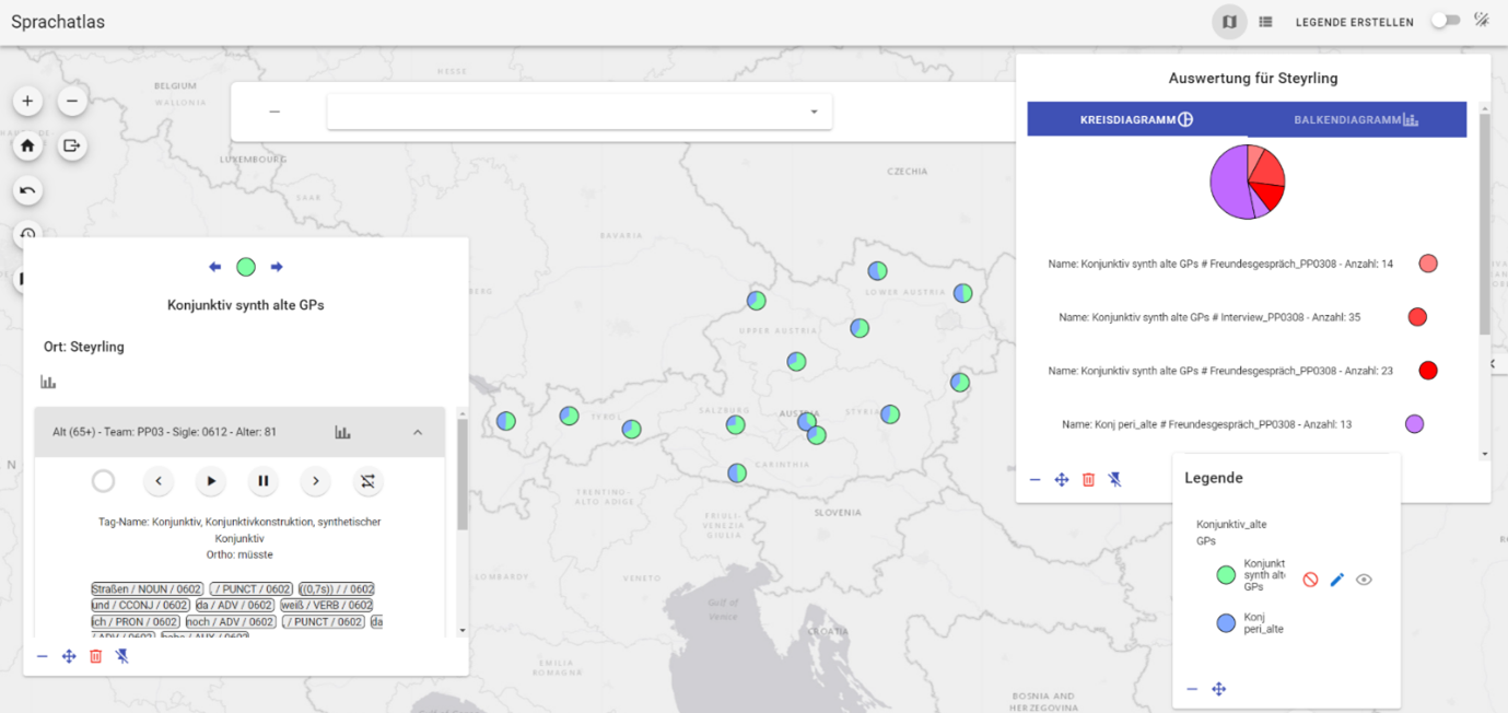
Ein moderner, variationslinguistischer Ansatz beinhält allerdings mehr als die geographische Verteilung verschiedener Varianten einer Variable. Auch die Variation innerhalb eines Individuums oder innerhalb eines Ortspunkts steht klar im Fokus. Für ein Kartierungstool ergibt sich dabei die Frage, wie diese Dimensionen zusätzlich zur arealen Dimension berücksichtigt und visualisiert werden können. Eine bisherige Lösung ist dabei die Visualisierung von Anteilen der verschiedenen Parameter pro Ortspunkt als Kreisdiagramm sowie die Visualisierung der Anteile der Parameter nach verschiedenen Filtern, wie beispielsweise Erhebungssetting oder Gewährspersonengruppe (siehe Abbildung 1).
Fokus des Vortrags soll dabei sein, inwieweit areale und inter- und intraindividuelle linguistische Variation sinnvoll in einem Zusammenhang gestellt werden kann, und ob (und wenn ja, wie) kartographische Darstellungen dies leisten können.
Literatur:
- Budin, Gerhard, Elspaß, Stephan, Lenz, Alexandra N., Newerkla, Stefan Michael, Ziegler, Arne (2018): “Der Spezialforschungsbereich ‘Deutsch in Österreich (DiÖ). Variation – Kontakt – Perzeption‘“, in: Zeitschrift für germanistische Linguistik 46, 2: 300–398 https://doi-org.uaccess.univie.ac.at/10.1515/zgl-2018-0017 [07.01.2024].
- Korecky-Kröll, Katharina, Anja Wittibschlager, Markus Pluschkovits, Florian Tavernier, Johanna Fanta-Jende, Rita Stiglbauer, Jakob Bal, Katharina Kranawetter & Rebecca Stocker (2023): „Erhebung, Aufbereitung und (kollaborative) Nutzung des Korpus "Deutsch in Österreich. Variation - Kontakt - Perzeption". In: Marc Kupietz & Thomas Schmidt. (eds.): Neuere Entwicklungen in der Korpuslandschaft der Germanistik. Beiträge zur IDS-Methodenmesse 2022. Tübingen: Narr Francke Attempto (= CLIP - Korpuslinguistik und interdisziplinäre Perspektiven auf Sprache 11), 143–157.
- Rabanus, Stefan (2005): “Sprachkartographie des Deutschen: Von Schmeller bis zum Digitalen Wenker-Atlas“, in: Di Meola, Claudio, Hornung, Antonie & Rega, Lorenza (eds.): Perspektiven Eins. Akten der 1. Tagung Deutsche Sprachwissenschaft in Italien (Rom, 6.-7. Februar 2004). Rom: Istituto Italiano di Studi Germanici, 345–363.
Geographische Namen als Kürzel für Raumkonzepte und verdichtete Erzählungen über den geographischen Raum
Peter Jordan, Österreichische Akademie der Wissenschaften, Institut für Stadt- und Regionalforschung
Geographische Namen sind zwar nicht Teile des Signaturensystems der Karte, also der ‚Kartensprache‘ im engeren Sinn, sondern eigentlich Fremdkörper im Kartenbild, erleichtern aber das Kartenlesen und erweitern die Aussagemöglichkeiten von Karten ganz wesentlich, informieren z.B. über Raumbegriffe wie Kulturlandschaften, die, wenn sie nicht zugleich politische oder administrative Einheiten sind und somit durch Verwaltungsgrenzen erkennbar werden, ohne sie aus einer Karte nicht hervorgingen.
Der Vortrag weist zunächst auf die vier wichtigsten Rollen geographischer Namen als Mittler zwischen Mensch und geographischem Raum hin: (1) Geographische Namen reflektieren oft (als deskriptive Namen, nicht als Gedenknamen) Merkmale des geographischen Raumes, sind ‚verdichtete Erzählungen‘ über ihn und beschreiben das Wesentliche oder das Außergewöhnliche eines geographischen Objekts; (2) sie markieren (als Endonyme im Sinne von geographischen Namen, die von der örtlichen Gemeinschaft verwendet werden, nicht als Exonyme im Sinne von Namen, die außerhalb der örtlichen Gemeinschaft für ein Objekt auf deren Territorium verwendet werden) das Territorium einer Gemeinschaft; (3) sie unterstützen die begriffliche Strukturierung den geographischen Raumes, also raumbezogene Begriffsbildung, und ermöglichen die Kommunikation über ein raumbezogenes Begriffssystem und dessen Weitergabe; (4) sie unterstützen die emotionale Bindung zwischen Mensch und Raum und damit raumbezogene Identitätsbildung.
Sodann nennt der Vortrag die Funktionen von geographischen Namen in Karten, wobei zwischen Funktionen für Leser, die den Namen und das von ihm bezeichnete geographische Objekt nicht kennen und solchen, die ihn/es kennen unterschieden wird. Demnach erleichtern geographische Namen Lesern, welche Namen und Objekt nicht kennen, das Kartenlesen; ermöglichen ihnen mit Hilfe des Ortsnamenregisters eines Atlasses oder die Suchfunktion eines digitalen Kartenwerks die Suche nach geographischen Objekten; informieren über die kartographische Signatur hinaus, die immer nur stark abstrahierend grobe begriffliche Kategorien reflektieren kann, über die Eigenart des dargestellten geographischen Objekts. Sie informieren schließlich auch über die Kultur eines Ortes und Gebiets, nicht allein deshalb, weil sie einer bestimmten Sprache angehören, sondern auch, weil sie oft Fossilien älterer Sprach- und Kulturschichten sind. Für Leser, die mit dem in der Karte vorgefundenen Namen und dem von ihm bezeichneten geographischen Objekt schon vertraut sind, stehen die geographischen Namen zusätzlich wie ein Logo oder Wappen symbolhaft für einen komplexen Begriffsinhalt. Sie können auch emotionale Bindungen zum geographischen Objekt unterstützen, z.B. zu einem Heimatort oder zu einem anderen Ort, den der Leser gut kennt und den er mit eigenen Erlebnissen verbindet.
Der Vortrag ist dem Fachgebiet der Toponomastik im Sinne des Studiums von Eigennamen geographischer, raumgebundener Objekte zuzuordnen, die ein interdisziplinäres Forschungsfeld ist, zu welchem neben der Linguistik auch die Geographie, die Kartographie, die Geschichtswissenschaften und die Kulturanthropologie maßgeblich beitragen. Er hebt dabei kartographische Aspekte hervor.
Exploring the WIBARAB database: a linguistic map of spoken Arabic
Veronika Engler, Österreichische Akademie der Wissenschaften, Austrian Centre for Digital Humanities and Cultural Heritage
Karlheinz Mörth, Österreichische Akademie der Wissenschaften, Austrian Centre for Digital Humanities and Cultural Heritage
Daniel Schopper, Österreichische Akademie der Wissenschaften, Austrian Centre for Digital Humanities and Cultural Heritage
Kinga Sramó, Österreichische Akademie der Wissenschaften, Austrian Centre for Digital Humanities and Cultural Heritage
WIBARAB (What is Bedouin-type Arabic?) is an ERC-funded project that investigates the linguistic and socio-historical realities behind the millennia-old dichotomy between nomadic and sedentary communities in the Middle East and North Africa. The project uses a combination of methods based on Arabic dialectology, general linguistics, sociolinguistics and geolinguistics. An essential part of the project is the development of a linguistic feature database of over 300 varieties of spoken Arabic. One of its novel features is that all the linguistic data has been modelled in accordance with the Guidelines of the Text Encoding Initiative (TEI), which has allowed a high degree of flexibility during the combined collection and development process. The data will be made accessible through an interactive map using the geospatial data available in the database. Maps are widely used in the narrower field (e.g. VICAV) but also in general linguistics (e.g. WALS Online). The map of the WIBARAB database is intended to visualise linguistic facts about a wide range of spoken varieties, the varieties having been selected for their relevance to answering the specific research questions of the project. And while there are many templates for designing the details of such an exploratory tool, creating an easy-to-use and reasonably intuitive query interface, the specific needs of combining multiple features on a single map and the difficulties of representing fuzzy, not precisely delineable linguistic phenomena still pose unresolved challenges.
The WIBARAB multi-feature map will need to address at least three specific aspects of the underlying data. (1) There is a significant amount of overlap between different feature values, in other words, there are many locations that have more than one feature value. This poses a serious challenge for visual representation on a map, particularly when multiple linguistic features can appear in an open number of possible combinations. (2) The data requires the visualisation of both precise locations as well as regions with more vague boundaries with a contrast of large amounts of data in particular locations and significant gaps in other locations. (3) The project also has a micro-diachronic dimension as the data used in the project covers a period of approximately 125 years, requiring the ability to filter the data according to historical periods.
Versuch eines triadischen geographischen Raummodells zur Bewältigung aktueller gesellschaftlicher Krisen
Andreas Koch, Universität Salzburg, Fachbereich Soziologie und Sozialgeographie
Eine grobe historische Einordnung geographischer Räume lässt eine bemerkenswerte Transformation ihrer Merkmale erkennen. Ausgehend von raumwissenschaftlichen Ansätzen im ausgehenden 19. Jahrhundert, die dem Raum eine eigenständige Wirkung – bis hin zu einem Raumdeterminismus – für soziales Handeln unterstellten, haben sich bis in die heutige Zeit sukzessive sozialwissenschaftliche Ansätze etabliert, die das soziale Handeln – bis hin zu einem Sozialdeterminismus – in den Mittelpunkt stellen und Raum als außerhalb ihrer sozialen Systemgrenzen liegend abstrahieren. Beide extreme Raumparadigmen scheinen wenig geeignet, dem Erkenntnisgegenstand Raum im persönlichen wie gesellschaftlichen Leben gerecht zu werden.
Vor dem Hintergrund eines weitgehend entfremdeten Naturverhältnisses (z.B. Klimakrise), einer zunehmenden Kommodifizierung sozialer Güter (z.B. Wohnraum), aber auch einer mitunter problematischen Verwendung mancher Raumkonzepte (z.B. Territorium), stellt der Beitrag einen alternativen Ansatz vor, der geographischen Raum als nicht-holistische Synthese (i) der natürlichen und gebauten materiellen Umwelt, (ii) der sozialen Beziehungen im territorialen und relationalen Raummodell und (iii) der sprachlichen und (karto-)graphischen Repräsentation in sozialen Kommunikationsprozessen versteht. Damit verbunden ist der Versuch, reduktionistische Vorstellungen von Raum – als rein materiell, rein territorial, rein sprachlich vermittelt – einer kritischen Reflexion zu unterziehen und damit einen geographischen Beitrag zur sozialökologischen Transformation von Gemeinschaften zu leisten.
Date
23 April 2024, 09:00-17:00
Place
Austrian Academy of Sciences
Sonnenfelsgasse 19
Theatersaal
1010 Vienna